Trail Mountain bike Le Sauze-du-Lac - circuit N°28 balcon du sauzee - Photo
 guariso
guariso

User

© OpenStreetMap contributors
Length
Length
8.2 km
Max alt
Max alt
1045 m
Uphill gradient
Uphill gradient
319 m
Km-Effort
Km-Effort  
12.5 km
Min alt
Min alt
788 m
Downhill gradient
Downhill gradient
321 m
Boucle
Boucle
Yes
Creation date :
2018-09-22 21:35:54.103
Updated on :
2018-09-22 21:35:54.103

(0 Reviews)

Mountain bike
Mountain bike
1h03
Difficulty : Difficult

Scan this QR Code to open this trail in the SityTrail application

FREE GPS app for hiking

Logo SityTrail SityTrail

IGN / Geographical institutes

Download SityTrail from the App Store Download SityTrail from Google Play

Logo SityTrail SityTrail World

The world is yours!

Download SityTrail from the App Store Download SityTrail from Google Play Download SityTrail on Huawei AppGallery

About

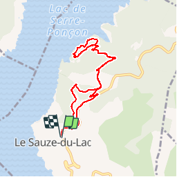
Trail Mountain bike of 8.2 km to be discovered at Provence-Alpes-Côte d'Azur, Hautes-Alpes, Le Sauze-du-Lac. This trail is proposed by guariso.

Description

le circuit débute par une descente en petit chemin, pierreuse mais pas très technique, puis une longue descente en petite route goudronnée. ensuite une partie en sous bois, la partie descendante est agréable, pas technique, mais s'enchaînent ensuite des petites montées assez physique, bien pentues qui alternent avec du plat. la remontée en sous bois est ensuite très physique.. séance cardio garantie ! la fin de montée se fait sur route goudronnée. je mets difficile car les montées sont raides même si la rando est courte.

Elevation profile

Positioning

Country:
France
Region :
Provence-Alpes-Côte d'Azur
Department/Province :
Hautes-Alpes
Municipality :
Le Sauze-du-Lac
Location:
Unknown
Start:(UTM)
286488 ; 4928605 (32T) N.

Trails nearby

Trail Walking Ubaye-Serre-Ponçon - le clôt de la cime. - Photo
Walking
GILOU440

Walking

Easy
(1)
Ubaye-Serre-Ponçon, Provence-Alpes-Côte d'Azur, Alpes-de-Haute-Provence, France
12.5 km | 19.8 km-effort
4h 0min
Yes
Trail Walking Ubaye-Serre-Ponçon - Circuit de l'Escoubaye 25 -12- 2014 - Photo
Walking
Dervalmarc

Walking

Easy
(1)
Ubaye-Serre-Ponçon, Provence-Alpes-Côte d'Azur, Alpes-de-Haute-Provence, France
6.9 km | 10.1 km-effort
2h 32min
Yes
Trail Walking Chorges - Chanteloube et lac de Serre Ponçon - Photo
Walking
gildascb

Walking

Very easy
(2)
Chorges, Provence-Alpes-Côte d'Azur, Hautes-Alpes, France
5.9 km | 8.2 km-effort
1h 47min
Yes
Trail Walking Chorges - clôt c l'avais sur fein - Photo
Walking
Didier.kiehl

Walking

Very easy
(2)
Chorges, Provence-Alpes-Côte d'Azur, Hautes-Alpes, France
8 km | 12.6 km-effort
2h 24min
Yes
Trail Walking Pontis - PONTIS , le dolmen  - Photo
Walking
RobinMicheline

Walking

Medium
(1)
Pontis, Provence-Alpes-Côte d'Azur, Alpes-de-Haute-Provence, France
12.9 km | 21 km-effort
3h 50min
Yes
Trail Walking Pontis - Le Grand Morgon par la face nord 07/09/23 - Photo
Walking
GUIDE
R@ph

Walking

Difficult
Pontis, Provence-Alpes-Côte d'Azur, Alpes-de-Haute-Provence, France
7.8 km | 18.9 km-effort
4h 18min
Yes
Trail Walking Pontis - Morgon par les Traverses, retour par les Ortals - Photo
Walking
GUIDE
David25400

Walking

Very difficult
Pontis, Provence-Alpes-Côte d'Azur, Alpes-de-Haute-Provence, France
17.1 km | 33 km-effort
5h 49min
No
Trail Walking Pontis - Le Morgonnet - Photo
Walking
GUIDE
Specialized77

Walking

Medium
Pontis, Provence-Alpes-Côte d'Azur, Alpes-de-Haute-Provence, France
5.9 km | 10.6 km-effort
2h 46min
Yes
Trail Walking Pontis - Morgon par les Ortals - Photo
Walking
GUIDE
David25400

Walking

Difficult
Pontis, Provence-Alpes-Côte d'Azur, Alpes-de-Haute-Provence, France
15.6 km | 32 km-effort
6h 29min
Yes


Close
My subscriptions